

-
Partager cette page
Disentangling diffuse vs. concentrated erosion in total soil exports over the Holocene: combining erosion models, sediment proxies, remote sensing and geophysics
Article co-signé Florence Mazier
Publié le 24 août 2026 – Mis à jour le 24 août 2026
The study shows that concentrated erosion contributed up to 46% of total Holocene soil erosion in the Lake La Thuile catchment, highlighting the need to account for intensive erosion processes when assessing long-term soil and nutrient exports.
Over the past millennia, human activities and land clearing have significantly altered land cover, accelerating both diffuse and concentrated erosion of soils, ultimately threatening soil ecosystem services. While numerous studies have emphasized on diffuse erosion, the understanding of concentrated soil erosion through incisions remains limited and has rarely been quantified over long-term periods.
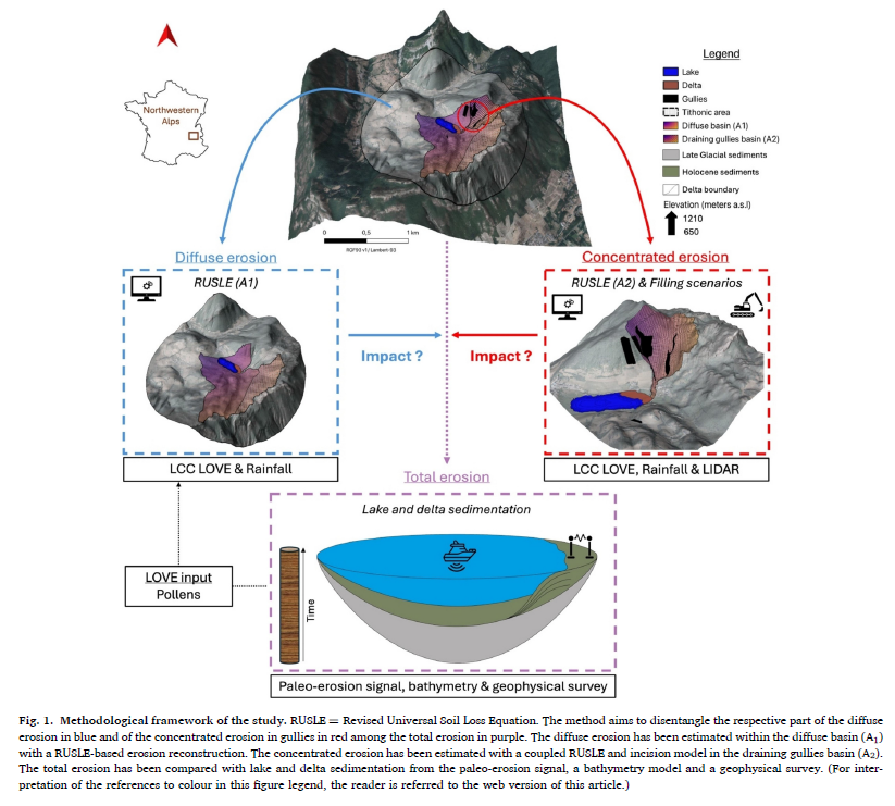
This study quantifies both concentrated and diffuse erosion to differentiate their respective contributions to the total erosion within the Lake La Thuile catchment in the northwestern Alps, linking spatial and temporal data. The RUSLE model was used to estimate past diffuse erosion.
The RUSLE model was temporally constrained with Land Use Land Cover (LULC) reconstruction from the pollen-driven LOVE model to assess the effect of land opening on soil erosion during the Holocene. Concentrated erosion was evaluated by quantifying contemporary land incision using high-resolution LIDAR land surface elevation data.
Furthermore, basin sedimentation was assessed with both paleoerosion signal and geophysical investigations. Our results highlight a significant contribution of concentrated erosion, corresponding to up to 46% of the total Holocene erosion exports.
This underscores the importance of accurately quantifying the contributions of intensive erosion processes in long-term assessments of soil erosion and/or nutrient exports to avoid misestimating terrestrial fluxes in the critical zone.
This study quantifies both concentrated and diffuse erosion to differentiate their respective contributions to the total erosion within the Lake La Thuile catchment in the northwestern Alps, linking spatial and temporal data. The RUSLE model was used to estimate past diffuse erosion.
The RUSLE model was temporally constrained with Land Use Land Cover (LULC) reconstruction from the pollen-driven LOVE model to assess the effect of land opening on soil erosion during the Holocene. Concentrated erosion was evaluated by quantifying contemporary land incision using high-resolution LIDAR land surface elevation data.
Furthermore, basin sedimentation was assessed with both paleoerosion signal and geophysical investigations. Our results highlight a significant contribution of concentrated erosion, corresponding to up to 46% of the total Holocene erosion exports.
This underscores the importance of accurately quantifying the contributions of intensive erosion processes in long-term assessments of soil erosion and/or nutrient exports to avoid misestimating terrestrial fluxes in the critical zone.